Wednesday, June 30, 2010

Day 23: Halifax, NS to Charlottetown, PEI

Day 23

Miles 184 (6764)
Two Lanes 178 (5505) 81%
Top Down 184 (5901) 87%


OK, that was the best bed i have ever slept on. Pillow top and down comforter. I did not want to get out of bed. So if you are ever in Halifax, stay at the Prince George Hotel.

We ate a great Berkeley/European/Eclectic breakfast at a coffee house near the University: Steve-a-Reno's. Linda had an oatcake that I should prescribe for constipation. It was oats glued together with honey and weighed about a ton. I quickly got out the map and starting marking restroom stops.

We drove down the coast (down is up....since the Gulf of mexico current flows northeast, the locals call 'up' on the map 'down'. We then turned in and drove the the Caribou to Woods Island ferry. 75 minutes to Prince Edward Island.

PEI is known for cows, milk, mussels, oysters, and potatoes. The land is very green and cultivated. We arrived in the capital, Charlottetown, at about 7 and checked into our B&B.


Living History at the Fortress in Halifax


Another ferry! This one is 75 minutes long and takes us to Prince Edward Island, Canada's smallest province.


Into the Harbor at Woods Island, PEI


Out of the bowels of the ship....


PEI is pastoral


The Elmwood, our home for two nights.

Tuesday, June 29, 2010

Day 22: Newfoundland to Halifax, Nova Scotia

Day 22

Miles 266 (6580)
Two Lanes 164 (5327) 81%
Top Down 0 (5717) 87%


Day 22: Crossing the Cabot Strait.
.
Up early to board the M V. Caribou of the Atlantic Maritime Fleet from Port aux Basques back to North Sydney, Nova Scotia. The ship is 587 feet long and runs at about 20 mph. It carries 370 cars, 77 tractor trailers, and up to 1,200 passengers.

The trip crosses the ‘narrow neck’ of water between southern Newfoundland and northern Nova Scotia called the Cabot Strait. It is 110 miles across and takes about 6 hours for the Caribou to cross. Today she entered fog quickly after leaving Port aux Basques. We listened to the soft moan of her foghorn as we looked out at the never changing view. Visibility was about 50 feet. I was grateful for radar and GPS. Sailors before about 1950 did not have radar. It was invented by and for military use in WW II and did not get into non-military ships until the fifties.

The crossings are not always six hours long. This ferry is the year round link between Newfoundland and the mainland of North America. I spoke with Charlotte, who works in the coffee shop on board. She lives in Port aux Basques and traveled the ferry long before she worked on it. Our crossing was very smooth. I asked her what the crossings are like in the winter.

“It can be bad. The worst are the high winds and seas. But then there is the ice.”

“Ice…across this wide strait?”

“Oh yes. Sometimes up to three feet thick. Now these are icebreakers: Northern Baltic Class 1A. They are built to do it. One time it took us 18 hours to cross.”

Quickly doing some math in my head I said, “ That’s still about 6 knots through the ice.”

“Well that may be the average but it’s really more of going forward fast, ramming the ice, backing up and doing it again, over and over and over. The sound of the ice scraping along the hull is God-awful. And then it again it doesn’t always work. In April of 2008 the Smallwood got stuck in the ice and had to be rescued by Canadian naval ice breakers.”

Now that would be a crossing to tell your grandkids about.


After our arrival in Nova Scotia our route to Halifax took us within a couple of miles of Alexander Graham Bell’s Nova Scotia summer home. Born in Scotland, he immigrated to the US and became a citizen with his family as a young man when he was ill with tuberculosis. He recovered (his two brothers died). He invented the telephone at the age of 36 and went from rags to riches overnight. H did not consider himself a professional inventor like Edison. In fact, Bell often lost interest in an invention once he created it, and left the further development and marketing to others. What he really enjoyed was improving the inventions of others: for example, he improved Edison’s phonograph to there it could become a household item and he invented ailerons so airplanes could turn.
But what he considered to be his greatest achievement was work he did to help the deaf learn to speak. He was a contemporary and close friend of Helen Keller.

As we left it started to rain hard, and the top was up the whole day. Bummer.
Then into the fog of Halifax. It seemed like San Francisco. Halifax has been and still is a major naval port. During WW II convoys would assemble here before crossing the North Atlantic with supplies, troops and equipment. My father visited Halifax on his LST in 1943 before heading to Europe. We had a great dinner of halibut stew and a pint of Propeller Porter, then to bed.


Bound for Nova Scotia


Leaving the "Island", or as some locals aptly call it, the "Rock"


Arrival in Halifax (or is this San Francisco in the summer!)

Sunday, June 27, 2010

Day 21: Rocky Harbour to Port aux Basques, Newfoundland

Day 21

Miles 281 (6314)
Two Lanes 281 (5163) 82%
Top Down 281 (5717) 91%


After a lazy morning Linda took us on a walk to the beach in the southern part of the park to a place called "Green Gardens". . 3 miles each way. A walk it wasn't. A hike it was. A six mile round trip, we climbed up over a ridge and then down about 800-1000 feet to the ocean. In addition to some lovely patches through some fern glades, there were steep stretches and 425 steps. Had we known we likely would not have known. Sometimes it is best not to know. The destination was idyllic. Please see the photos. After about 30 minutes on the beach we climbed back up and and out and drove out of the park.

At Wiltondale, we stopped for a snack. here we met a great couple from Corner Brook, NL. Corner Brook is a slice of civilization in this part of the world, and is in the southwest part of the "Island". Randy and Hilga we out on their Harleys for a Sunday ride. They thanked us for "dropping by"

Then on to Port aux Basques to catch the ferry back to Nova Scotia in the morning. It was a gorgeous and memorable day.

Our 3 mile hike (6 miles round trip) down to the Gulf of St. Lawrence at "Green Gardens"


Ah, perfection in front of perfection!


Bonne Bay


Views from our room last evening


Saturday, June 26, 2010

Day 20: Halfway! Gros Morne National Park.

Day 20. Halfway.

Miles 63 (6033)
Two Lanes 51 (4882) 81%
Top Down 51 (5436) 90%

Today we spent the day in Gros Morne National Park on the west coast of Newfoundland. Gros Morne is a United Nations UNESCO World Heritage Site. What is a World Heritage Site?

To quote from the website:

“Heritage is our legacy from the past, what we live with today, and what we pass on to future generations. Our cultural and natural heritage are both irreplaceable sources of life and inspiration. Places as unique and diverse as the wilds of East Africa’s Serengeti, the Pyramids of Egypt, the Great Barrier Reef in Australia and the Baroque cathedrals of Latin America make up our world’s heritage.

What makes the concept of World Heritage exceptional is its universal application. World Heritage sites belong to all the peoples of the world, irrespective of the territory on which they are located.

The United Nations Educational, Scientific and Cultural Organization (UNESCO) seeks to encourage the identification, protection and preservation of cultural and natural heritage around the world considered to be of outstanding value to humanity. This is embodied in an international treaty called the Convention concerning the Protection of the World Cultural and Natural Heritage, adopted by UNESCO in 1972.”

The 20 sites in the US include Yellowstone, Glacier, Yosemite, The Statue of Liberty and Independence Hall.

So why Gros Morne?

Again to quote:

“Gros Morne National Park illustrates some of the world’s best examples of the process of plate tectonics. Within a relatively small area are classic, textbook examples of monumental earth-building and modifying forces that are unique in terms of their clarity, expression, and ease of access. The property presents the complete portrayal of the geological events that took place when the ancient continental margin of North America was modified by plate movement by emplacement of a large, relocated portion of oceanic crust and ocean floor sediments. The park also presents an outstanding demonstration of glaciation in an island setting. The fjords, waterfalls and geological structures of the park combine to produce a landscape of high scenic value.”

In fact, there is a joke in Newfoundland that the members of the Flat Earth Society (yes, it does exist) believe that Newfoundland is one of the four corners of the world.

We took two 6-mile hikes. One through a bog studded with wildflowers to a beautiful waterfall.

The other trail was through the limestone tilted on its side by the collision of two continents 460 million years, then past the fault line at the end of one of the continents, and onto a fresh water fjord. This fjord, Western Brook Pond is 7 miles long, 500 feet deep, and has water that is almost the clearest and cleanest in the world. It is surrounded by granite and has little sediment flow into it. And there is little human contact with it. No sediments, no nutrients. Nothing grows.

Then off to the local fish market at the wharf where the haul today included turbot. One pound…. Four dollars. We cooked it in our cabin and the rain began to fall.

Enough words. Enjoy the photo essay of Gros Morne.


Mrs. Moose just off our trail. Moose are not natural here. Two pair were brought in in 1904 and their population has swelled to over 100,000. The government is re-evaluating their protective policies since the moose eat native vegetation and destroy habitats, and were responsible for 660 vehicle collisions in Newfoundland last year. So sometimes you have to eat them. See Part 2.


Another beautiful wildflower just off the trail.


Baker's Brook Falls


The lovely couple.....


Wild Violet


Wild Iris


Moose Burgers. Yumm. Now we have had bison, elk, Goose...and Moose!


The Trail to Western Brook Pond


Western Brook Pond

Friday, June 25, 2010

Day 19: St. John's to Rocky Harbour (Gros Morne Natl. Park)

Day 19

Miles 460 (5970)
Two Lanes 406 (4831) 81%
Top Down 299 (5385) 90%


So how do you pronounce the name of this province? Most of us were taught to put the accent on the first syllable and not to pronounce the ‘ou’ sound in the second syllable. (NEW-fund-land). But that is not how the locals say it. They pronounce it New-fund-LAND with the accent on the last syllable. A minor accent is on the first. There is almost a lilt at the end. This might be because this province has a large Irish population, and the name is said with a bit of an Irish accent. However you say it, don’t put the accent on the middle syllable, as many non-Newfoundland Canadians do. According to our guide on the puffin boat yesterday, that way is “clearly wrong!”

We left St. John’s on a rainy morning to drive across ”The Island,” as the locals call Newfoundland. Driving on Transcanada 1 from the east end, we headed to Rocky Harbour, 439 miles away. We have now been at the most western and most eastern termini of the “TCH”: Victoria, BC and St. John’s.

We passed the exit for (and you can’t make this stuff up): Dildo, Heart’s Desire, Heart’s Delight, and Heart’s Content. It must get lonely while those fishermen are at sea, but at the end is “Content”.

Next we passed the turn off for the ferry to St. Pierre and Miquelon Islands. Following the defeat of the French at the hands of the British in Quebec to end the Seven Years War (1763), the peace treaty left these two islands to France and the English took the rest. Later in 1803 the Louisiana Purchase gave the lands from the Mississippi to the Rockies to the US. So out of the vast amount of lands controlled by the French (eastern Canada and the Mississippi and Missouri Valleys) before 1763, all that is left today of French territory in North America are these two islands, located 16 miles off the Newfoundland coast and measuring in total 93 square miles of granite. St. Pierre Island is reported to still retain the wrought iron balconies and the flare of the French.

Then off to Gander, the last airport in North America before you cross the Atlantic. Gander has much history, some heroic, some tragic. It was important in World War II as a resupply base and as a base for anti-submarine air activities. On Sept. 11, 2001, when all US airspace was closed after the Twin Towers attacks, this little town played host to more than twice its population for several days. You can read more about this in my posting from last year, or by googling “Gander Operation Yellow Ribbon.”

But in December, 1985, 259 members of the famous US 101st Airborne Division died when their plane crashed upon take-off after refueling here. It is ironic and tragic that these highly trained and famous paratroopers died inside their plane, and not from their dangerous jumps into enemy lands.

Much of central Newfoundland is the same Canadian Shield we drove through in Ontario. Small rolling hills dotted with lakes and covered with birches and evergreens to a height of about twenty feet…..for miles. But every once in awhile, you cross a broad flat gravel bottomed creek. Stony Creek outside of Grand Falls, NL is one of those. Fishermen were parked by the bridge. Clifford was getting his tackle ready to go out into the river. He has been fishing Stony Creek his whole life. The salmon here run in June and July and into early August. The seasonal limit to keep is four. Otherwise it is catch and release.

The Canadians understand fisheries better than we do. We make you throw back he small ones. They make you throw back the big ones. Here is the thinking. The big ones are the hardy rootstock they are proven survivors. They have the genes you want in the gene pool. So in Newfoundland anything over 63.5 cm long (25 inches) must be released. You can catch the small ones and keep them, but nobody does, because these would count towards the limit. The largest one Clifford has caught and kept was 7 pounds and 62.9 cm. The largest one he ever caught (and had to release) was 10 pounds and 68 cm. Mr. Hurlburt……ready to fish?

We arrived at Rocky Harbour in Gros Morne National Park (an UNESCO site…more about it tomorrow) about 8:30 pm and checked into our private cabin with a view of the sea. The sun was still high in the sky and would not set for another hour. I love summer in the Northland. Dusk at 10 pm is perfect.

I don’t normally talk about our dinners. But we bought fresh Atlantic salmon caught and packed today! We cooked it in the garlic olive oil that we have carried for 5900 miles. It was a gift from Pat Ransdell. That, along with a wild rice pilaf and salad, were the perfect preliminaries for the aptly named “Death by Chocolate” ice cream that Linda bought made by a Nova Scotia dairy (and shipped over here by ferry, like everything else not caught or made here.) Then we settled down to a card game played with the Jumbo sized cards for the hard of sight given to us by our nephew Bob!

The colored homes of St. John's


The central plateau of Newfoundland


Stony Creek


Clifford


250 miles from Rocky Harbour on the road north is where the Vikings first landed in America in about 1000 A.D. Vikings are also thought to have visited the Rocky Harbour area.


The road into Gros Morne


Sunset from our cabin


Our dinner, caught today, cooked by us in our cabin.

Day 18 Ferry to St. John's Newfoundland


Day 18

Miles 108 (5510)
Two Lanes 63 (4425) 80%
Top Down 108 (5086) 92%


After a late night listening to "Bugs and Debbie Greene" in he ar of the ship, we went to bed and awoke to a foggy day. At 1:30 we docked in Argentia, Newfoundland. We drove to Bay Bulls to board a 45 foot boat for the trip to Gull Isalnd to see te puffins! And did we see puffins. There are 250,000 puffins here. The nesting pairs mate for life and dig a burrow about 6 inches into the hillside. The when the single egg is laid, the parents take turns watching the nest while the other goes out and gets fish to bring back. When the chick is able to fly, he/she does does not return toe land for 3 years, spending it all at sea. The bachelors hang out on the rocks looking for mates. It is amazing how similar species are!

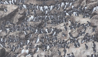
There are also 750,000 murres.

Then onto Cape Spear, the farthest easterly point in North America.

After we checked in to our hotel, we went to dinner and then to famous Geroge Street, the home of pub crawls. And it was hopping. We paid our cover and went into one, and again hit the sack after midnight. Parents can party.


Yes, Newfoundland is as far away from Disneyland as you can get!


Entering the harbour


Tying up


We made it!


Murres.........count 'em!


Clear the runway!


Chillin'


The bachelors


The nesting pairs


Cape Spear, the most easterly point in North America


St. John's Harbour